ENTRY 7: Cusco, The Inca Trail to Machu Picchu, and a return to Colombia
From Arequipa, another overnight bus delivered me to Cusco in the early hours of the morning. I had planned my arrival so that I would have two full days in Cusco before departing on the 4-day Inca Trail trek that I had booked the month before. While in Cusco I chose to stay at the Loki hostel - a popular chain of backpackers’ hostels in South America known for their party atmosphere (a fact I had cause to regret when trying to get to sleep), but good for meeting new people, and the staff were extremely helpful in all things.

One of many churches
Cusco is another town of well-preserved Spanish colonial architecture, although perhaps not as charming as the old town in Arequipa. Because of the constant influx of tourists seeking to visit Machu Picchu and the other Inca sites of the nearby Sacred Valley, the centre of Cusco is almost exclusively geared around tourism, with endless street vendors hassling you to buy anything and everything from oil paintings to massages. In contrast to my previous experiences travelling in South America, Cusco is literally swarming with foreigners, and higher prices reflect that fact.
I had intended to spent the two days sightseeing, but the first was occupied with various bits of admin for the trek including various “extras” the company (SAS) insisted on charging me for. The second day I resolved to at least see some of the sites, but discovered that to visit any of them, foreigners have to buy a tourist ticket which costs 130 soles (about £35) - I felt this was extortionate so went for a walk up into the surrounding hills that overlook the city. Here I found the Inca fort of Sacsaywaman, and was also able to discover a way in which avoided the ticket booth. I amused myself for a couple of hours before crossing to another nearby hill from which a large statue of Christ on the Cross (with rather creepy eyes) looks down over Cusco. That evening the trekking company held a briefing to explain our route and the various arrangements for the next 4 days.
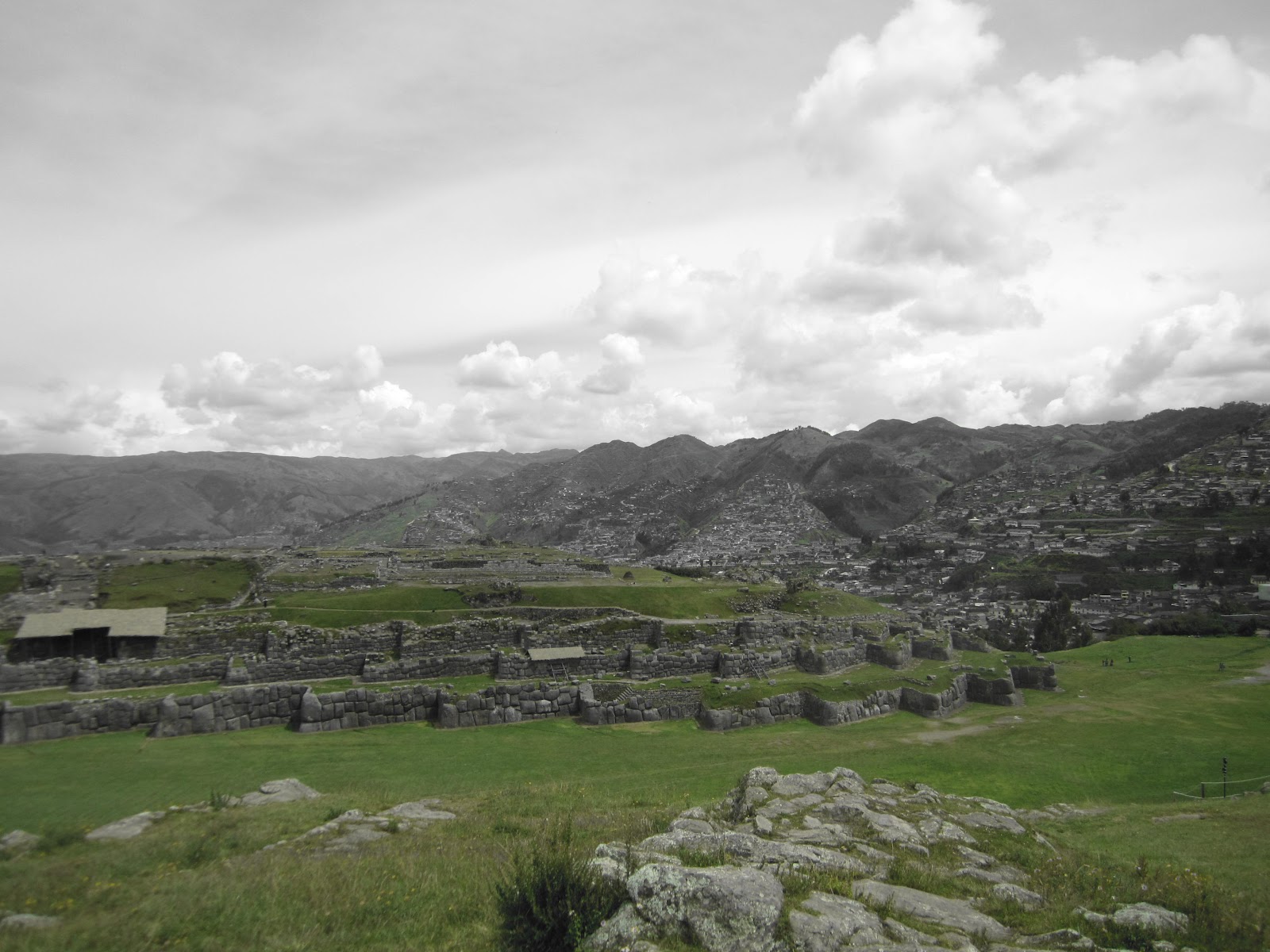
Walls of the Inca fort Sacsaywaman, with Cusco in the background
On the morning of my third day I roused myself at 0400 and was collected at 0500. I had already briefly met my fellow trekkers at the briefing the previous night. After an hour or so of driving we stopped at a shop/cafe to have breakfast, and the tour guide exhorted us to buy various “essentials" such as rain ponchos, coca leaves, and Gatorade (this would be a frequent feature of the trek, as there were a surprising number of “last” stops to buy such necessities...). I did buy some coca leaves for the novelty value (although I ended up not using them). Over breakfast I got to know a few of my group a bit better, discovering a mix of British, Australians and Americans, and one Caribbean. After another hour or so by road we reached the starting point of the trail (“Kilometro 82”). The 13 trekkers and the 20-odd porters all set to work sorting packs and bags, and I noticed that I seemed to be the only non-porter carrying anything larger than a daysack. It seemed I was the only person in the group not to have paid an extra $50 for a “personal porter” to carry a (heavy) sleeping bag, mattress and various other items for me. As it was too late to worry about that I decided to just crack on and see how things went.
In recent years the Peruvian government has brought in strict guidelines in order to preserve its most famous tourist attraction. Only 500 visitors and guides/porters can start on the Inca Trail each day, so before we could start, we had to have our passports and tickets checked, which meant queuing for half an hour or so, as the porters went on ahead to set up camp for lunch.

Trekkers (14) and most of the porters (about 18 in total)
We set out along a relatively flat path following the course of the Urumbamba River, on the opposite bank to the train line to Aguas Calientes, which follows the route of the original Inca trail. Our guide periodically stopped us to give us some historical bits of information, about the history of the trail both in relation to the Incas and in more recent years as its popularity has grown and how this has impacted o it.
As we went on, the path began to climb, until we crossed a small stream and then climbed a fairly steep path cut into the side of a hill to reach a lookout point over the valley below. From here we continued to climb until we overlooked the first Inca site along the trail, the religious centre of Patallacta. Along with several other tour groups we paused here for 10 minutes or so to take photos, and it was at this point that I noticed my group seemed to be the only one not made up exclusively of people in their teens/twenties... We carried on for another hour, descending on the other side of the hill until we reached the site for lunch, where the porters had pitched the dining tent, and laid out basins of water for us to wash our hands (which was a bit of a surprise as I was expecting a more rough-and-ready style of camping). We sat down to the first of what would prove to be excellent meals considering they were all prepared with ingredients and equipment that the porters had to carry every step of the way. After lunch we set off again, and I found that I was outpacing the rest of my group, aside from the front guide who I suppose who had no choice but to keep up with me. This would become a frequent feature of the trek, as the advantage of being at least 5 years younger than anyone in the group, and a naturally quick walking pace ensured that I would always be some way ahead of the group.
As we went on, the path began to climb, until we crossed a small stream and then climbed a fairly steep path cut into the side of a hill to reach a lookout point over the valley below. From here we continued to climb until we overlooked the first Inca site along the trail, the religious centre of Patallacta. Along with several other tour groups we paused here for 10 minutes or so to take photos, and it was at this point that I noticed my group seemed to be the only one not made up exclusively of people in their teens/twenties... We carried on for another hour, descending on the other side of the hill until we reached the site for lunch, where the porters had pitched the dining tent, and laid out basins of water for us to wash our hands (which was a bit of a surprise as I was expecting a more rough-and-ready style of camping). We sat down to the first of what would prove to be excellent meals considering they were all prepared with ingredients and equipment that the porters had to carry every step of the way. After lunch we set off again, and I found that I was outpacing the rest of my group, aside from the front guide who I suppose who had no choice but to keep up with me. This would become a frequent feature of the trek, as the advantage of being at least 5 years younger than anyone in the group, and a naturally quick walking pace ensured that I would always be some way ahead of the group.

Inca terraces at Patallacta
The rest of the afternoon was spent steadily climbing, stopping at another checkpoint. We reached our campsite about 1700 to find the porters had already made camp and those with their own porters had had their mattresses and sleeping bags laid out. We settled into our two-person tents; I was sharing with a 26-year old Geophysicist from Trinidad, who had studied in the UK (we had gotten talking as it turned out he had been rejected from Cambridge). The only downside about the accommodation was the toilet facilities, which were squats, and by the end of the evening seemed to have presented a number of people with problems...
That night (and the second) was fairly uncomfortable, as due to the elevation at which we were camping the temperatures plunged during the night. I had decided against hiring a sleeping bag as I had brought my own, and didn’t want to pay another $40. Unfortunately it was nowhere near as thick (or heavy) as the ones the company provided, and even with all my clothes on I was still woken up by the cold. I realised that I should have packed more warm layers, but when I had initially packed for my three months away I hadn’t really considered how cold it might get...

View from campsite No. 1
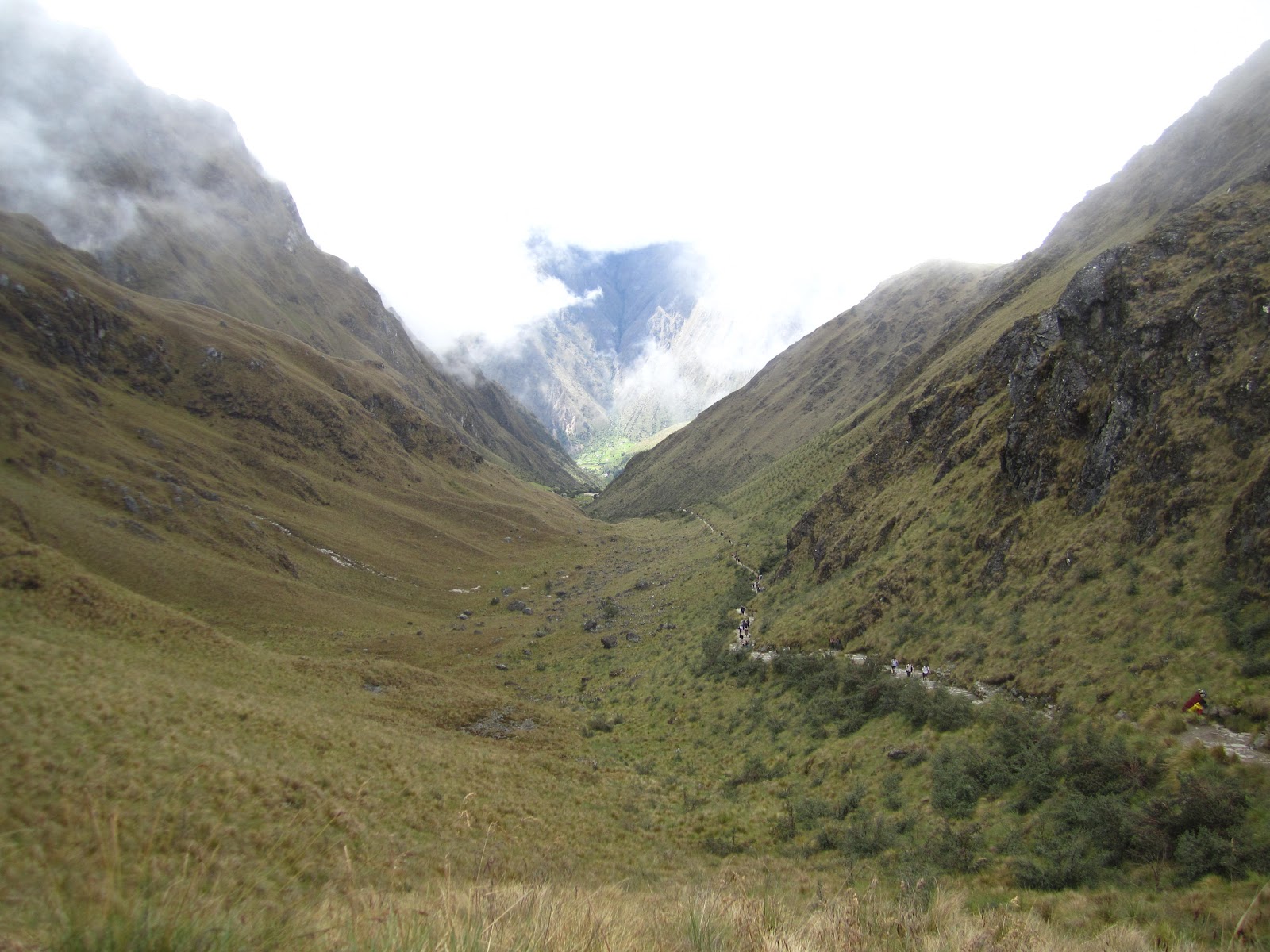
The next morning we woke to the spectacular sight of the mountains around us, and the knowledge that today would be the hardest of the four days in terms of effort required, due to the fact that to reach the next campsite, we would have to ascend and descend two different mountains, the first of which is home to ‘Dead Woman’s Pass”, the highest point in the Inca Trail, at 4200m, and named after the mummified body that was discovered there when the trail was first cleared in the 1920s. From the campsite to the Pass was an unbroken climb. We set off after breakfast, and as had been the case the previous day, I was soon ahead of the rest of the group. The first hour or so of the climb was through “cloud forest", with the path following the course of a river that ran down through the valley. At the first rest point, from where one could see the Pass, I waited for the rest of the group to catch up before we got going again. The next hour was extremely hard work as the climb steepened (something the photos really don’t do justice to, but most of it is essentially a stone staircase), and which acted as a bottleneck on the various groups going the same way. The last 15 minutes or so were particularly unpleasant, as one could see and hear the people who had set out earlier and had already reached the summit, while I was still climbing. I eventually hauled myself to the top, and settled down to a half hour wait until the next few members of my group arrived, rapidly donning more layers as the warmth from the climb wore off, and I realised how icily cold it was.

Looking up the trail to Dead Woman’s Pass, the highest point on the Inca Trail
View looking back along the trail from Dead Woman’s Pass
After about an hour or so we were all accounted for, and after a snack break and some photos we set off down the opposite side of the hill towards our lunch spot. The opposite side of the mountain seemed steeper than the one we had just climbed, and was heavy-going on the knees. Eventually, I decided to follow the example of the porters (who seem to be part mountain goat) and risk running down, which was much easier, but again left me far ahead of my group. After an hour and a half I reached the lunch site, 600m below Dead Woman’s Pass, where the porters had once again got everything ready, and I settled down to wait for everyone else with my book. My haste was rewarded as while I was waiting it began to rain extremely heavily, if only for a short while, and meant many of my group arrived soaking wet and were visibly steaming during lunch.
After lunch it was time for the second of the day’s mountains. As we climbed we looked back to see the lunch site was completely engulfed in thick cloud. We stopped at an Inca guardhouse for a break and another lecture from our guide. As we set off again the members of my group under 30 began a game seeing if they could catch me on the uphill climb, so I dutifully put on a burst of speed to prevent the gap from closing. After passing a small lake formed from rainwater (the Cochapata lagoon), we eventually reached the summit at 3950m, which was entirely shrouded in cloud, with visibility of around 10 metres at the most. We took shelter in a natural cave formed from fallen boulders as we waited for the rest of the group to arrive. From there we descended, getting caught once again by the rain. From this point the scenery began to change from relatively bare mountain and scrub to lush foliage as we entered the high jungle, and it became noticeably warmer.

Temple of the Rainbow
As we neared our campsite for that night, several of us took a detour to visit some nearby Inca ruins, which our guide told us was originally the “Temple of the Rainbow”, as apparently the Incas believed rainbows to be symbols of fertility. The cloud gave the ruins a brilliantly spooky atmosphere, and deadened the noises of the nearby jungle. After half an hour or so we set off after the rest of the group who had carried on ahead, passing another Inca watchtower before reaching our campsite. The second campsite was spectacularly located on a rocky bluff overlooking jungle-covered valleys, and with a view back towards the temple which was visible from the tents when the cloud cleared.

View from campsite No. 2 in the morning - you can just make out the temple perched on the rocky spur
The third day was to be mostly descending to reach our last campsite. We set out on a winding path along the side of a mountain with views down into the untouched jungle valleys below, which we could actually see for once due to the absence of excessive cloud. Around mid-morning we stopped at another pass, from which it was possible to see the mountain (Huayna Picchu) which rears up behind Machu Pichu. Just below this was a complex of Inca buildings called Phuyupatamarka, which our guide informed us had been part of a temple devoted to astrological study.

Phuyupatamarka - apparently this was the Inca equivalent of an observatory
From the ruins the path plunged down into the valley below (dropping 1000 m), down steep rocky steps hewn from the rock, which were perilously slippery. Along the way I ran into a herd of Llamas that were grazing on the vegetation along the side of the path, and saw a number of brightly-cloured Butterflies. Eventually I reached the third and final night’s campsite. After an hour the rest of the group arrived, and following a chance to unpack and relax, we went for a late afternoon walk to visit another Inca site nearby. Our guide told us that the convex terraces at Wiñay Wayna were used for experimental crops and for the development of new agricultural techniques, and the remains are in remarkably good condition. We had also hoped to see fireflies as darkness gathered, but no such luck.

“Experimental” convex terraces at Wiñay Wayna
That night the porters prepared for us a final dinner (complete with cake!), and we bid them farewell, as this was as far as they would go with us. The next morning(ish) we were woken at 3am to get ready for the last day - the gate to the last section of the trail would open at 0500, and we had to be queued up beforehand. From the last campsite it is 2 miles to the “Sun Gate” (Intipunku), a high pass with spectacular views overlooking Machu Picchu. People I had met along my travels who had done the Inca Trail had recommended moving quickly in order to get to the Sun Gate for dawn and to beat the crowds. With this in mind, I told the guide my intentions and as soon as I had got my ticket stamped, set off at a run, over 2 miles of uneven and wet ground, passing all but one of the groups ahead (unsurprisingly I got plenty of odd looks from those I passed, but I was particularly pleased at being mistaken for a porter due to the fact that I was running and that I had a rucksack twice the size of everyone else’s). However, when I got to the Sun Gate I felt an utter tit - rather than the spectacle of Machu Picchu laid out before me, what I could actually see was a wall of impenetrable grey cloud. I therefore had an excruciatingly embarrassing half an hour as the people I had passed caught up, and I did my best to act nonchalantly...


What I had hoped to see from the Sun Gate... (apologies for having to cheat and steal a photo from someone else)
Feeling rather crestfallen I waited for the rest of my group to catch up and we began the descent from the Sun Gate to the Machu Pichhu site. Having been denied the view from above we had no real clue where we were in relation to it, so it was a surprise when I came out of a stand of trees to find dozens of people milling about on the edge of a hill overlooking another cloud. I recognised the hill from other photos I’d seen as the slope overlooking the city, and realised the wall of grey was in fact hiding the site entirely. By the time the rest of the group arrived the clouds had cleared slightly, so one could make out the indistinct shape of buildings amidst the greyness. Thankfully, after a while the cloud dissipated enough for some decent photos and the hundreds of people who had been waiting began to frantically snap away with their cameras. After at least an hour of this, we moved down to the entrance where the day-trippers (people who have not come in via the Inca Trail) enter the site, and our tour guide began to talk us through the various different areas of the site.
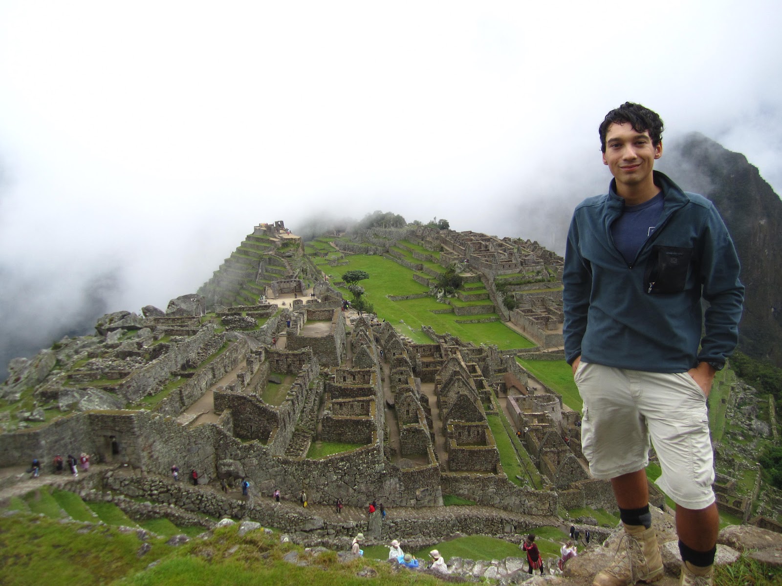
“the” standard Machu Picchu photo. Note the absence of blazing sunlight - you should be able to see another mountain in the background.
The “lost” Inca city of Machu Picchu is without a doubt South America’s most famous historic attraction. Its exact purpose is the subject of continued speculation, with the two most popular theories being that it was either a sacred religious centre (this was the version our guide told us), or that it was an estate for the Inca rulers before their fall. During the Spanish conquest of South America the invaders never reached Machu Picchu, and with the fall of the Incan empire knowledge of it was reduced to a few locals who had no reason to shout about it. “Re-discovered” (publicised) and named by the American academic Hiram Bingham just over a century ago (1911), its fame has since grown exponentially, and it continues to draw visitors in their thousands each day (2500 per day).
Although several hundred people arrive by the Inca Trail each day (the trail only closes in February to allow for repair), the rest come in from Cusco, or from the nearby town of Aguas Calientes. If anyone reading this ever finds themselves doing a day-trip to Machu Picchu at some point in the future, I cannot stress strongly enough to please KEEP OUT OF THE WAY OF THE TRAVEL-STAINED PEOPLE IN WALKING BOOTS CARRYING LARGE RUCKSACKS - there is a real resentment of day-trippers by the trekkers, as they feel they have earned the right to get there as early as possible, and not have their photos ruined by hordes of chattering tourists and school children. Originally, the Inca Trail was the only way to reach Machu Picchu, but its popularity led to the construction of a road to bus tourists in from Aguas Calientes.

It is almost impossible to take a photo at Machu Picchu without other tourists getting in the way
Although the buildings are extremely well-preserved considering their age, the site is heavily reconstructed, using the original material from the site itself, and the work is still ongoing. For an idea of what the site looked like before reconstruction work, have a look here: http://en.wikipedia.org/wiki/File:Machupicchu_hb10.jpg
After a couple of hours of being shephered around the site, myself and another member of the group went to climb Huanay Picchu, the mountain that looms above the city itself. Although more of our group were also supposed to come, problems with tickets (thanks to our tour guide’s incompetence) resulted in some frantic running about in order to fulfil the endless red-tape required by the site administrators, who dictate that only 400 people per day can ascend the mountain. Eventually we got through the gate and started the climb. The next 45 minutes were far more challenging than anything the Trail had thrown at us. The ascent itself is extremely steep (and slippery), up flights of narrow and irregular steps carved from the rock. Indeed, the steepness is such that most of the climb has various wires and ropes alongside to cling onto (“Via Ferrata”), without which the ascent (and descent) would be perilous. Unfortunately, I’ve already used the "Stairs of Cirith Ungol" analogy in a previous blog post, but it would have been more appropriate for this, as even the rock looked similar. Near the summit (2700 m, 350 m higher than the city) we reached the first of the Inca buildings. It is staggering that they went to the trouble of building in such a remote and innaccessible spot. The guides maintain that it was the home to the priests of the city below. To reach the summit, we had to crawl through a cleft in the rock and through a small opening on the other side, which I wouldn’t recommend for anyone with claustrophobia, as we had to remove our rucksacks and push them along in front if us to make it through the gap!

Looking down onto Machu Picchu from Huayna Picchu. As you can see, cloud was a big part of my Inca Trail experience
The top of Huanay Picchu affords spectacular views over the city below, as well as the imposing mountains and valleys that ring Machu Picchu. The drama is heightened by the steep drops on all sides from the summit. Indeed, the way down was, if anything, more nerve-racking than the climb, as one could see the drops off to the sides, and the steps were so narrow that one felt in constant danger of slipping. By the time we reached the bottom it was nearly time to go, so we made our way to the main gate and caught the bus down to Aguas Calientes, where we rendezvoused with the rest of our group for a late lunch and a few well-deserved drinks, before we went our separate ways.

Our motley crew
The journey back from Machu Picchu was pretty unremarkable, except rather than walking back to our starting point we took the tourist train, which follows the course of the river from Aguas Calientes. This is in itself an extremely pleasant ride through some beautiful scenery, although the tracks themselves could do with some work as it was the wobbliest train I’ve ever been on! I arrived back in Cusco around 2200, checked back into my hostel and attempted to get to sleep, only be woken up by the Israelis in my dorm returning drunk at 5 in the morning.
With Machu Picchu ticked off, it was time to start thinking about the homeward journey. I had a week and a half to get to Bogota for my return flight to Europe, so I began planning my journey North. From Lima I had originally intended to travel by land through Ecuador into the South of Colombia. Unfortunately, the proximity to Easter limited the availability of buses and flights, and I decided as I was already overbudget I could survive without seeing inland Ecuador (it was always my intention to return at some point in the future to see the Galapagos Islands). Without any need to rush, I therefore returned to Lima via a pretty epic 22-hour bus ride rather than forking out for a flight. The windiness of the road coming out of Cusco (in the pitch-dark) ensured it was impossible to get any sleep for the first few hours, and I once again had to deal with the ridiculously irritating game of Bingo the bus company insists on providing.


Another awesome sky in Lima
Arriving in Lima, I once again got in contact with the British mother and daughter I had stayed with previously, and spent the weekend in the city, venturing out to do some more sightseeing, but generally just lazing about and welcoming the chance to relax for a few days. From Lima I booked a flight to Bogota (the prices of which had risen due to the Easter holiday), where I would be meeting up and staying with my dad’s family for my birthday before flying home.
For my birthday I was treated to a meal at one of Bogota’s best restaurants, Andres Carne del Res, which is actually an hour’s drive from the city itself. The restaurant was bizarrely decorated, with various bits of paraphenalia littering the walls and ceilings. As it was Easter Sunday, there was an odd religious element to the atmosphere, with “halleluia” being played across the sound system at various points, and a troupe of masked figures in white were capering about the place with instruments. A mortifyingly embarrassing performance of "happy birthday" also left me draped in a sash and cardboard crown which I discarded as soon as possible. However, none of these incidents could detract from the food, which was fantastic. The restaurant specialises in meat so we all ordered steaks. The meat was incredibly flavoursome, and was pretty-much perfectly cooked. Aside from the courses themselves, one quirk of the restaurant was the continual stream of free fruit that kept appearing; from first coming into the restaurant and being offered strawberries to the small bowls of various grapes and other fruits, it all added a nice extra note to the meal.

Awesome meat
After my birthday I had two more days in Bogota until my flight home, which brings me up to the present moment (the first time my blog has caught up with me!). I’ll save conclusions/reflections on my trip as a whole until I get home, as this post is already too long. Suffice to say, I was extremely glad I left Machu Picchu until the end of my trip, as it made a suitable high point upon which to turn homewards.
NEXT TIME: 3 MONTHS AWAY - SO WHAT?
No comments:
Post a Comment